Organizational Maturity Model
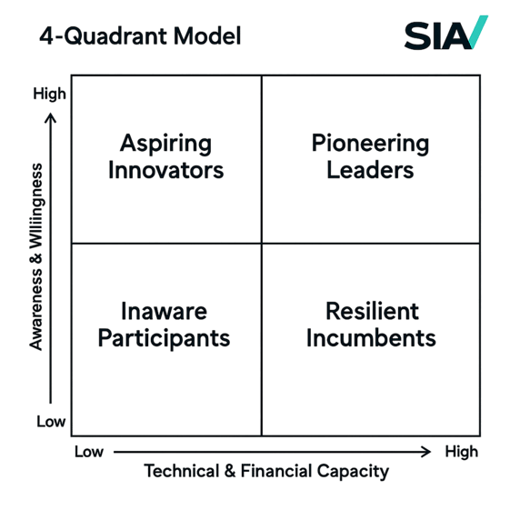
Our Four Quadrant Maturity Assessment Framework provides a comprehensive evaluation of an organization's strength as a data-driven entity, specifically tailored to determine its readiness to adopt and scale Earth Observation (EO) spatial data solutions. Using insights from extensive primary and secondary research, this framework positions organizations clearly within one of four maturity quadrants, providing actionable insights for advancement.
Measure Your Data-Driven Readiness
How the Assessment Works
Our structured diagnostic survey evaluates your organization across four key dimensions critical to spatial data adoption:


Financial Strength
Measures perceived adoption costs, available financial resources, and the organization's willingness to invest strategically in spatial data solutions.
Organizational Buy-in and Culture
Analyzes internal alignment, openness to innovation, and the overall level of employee awareness and engagement regarding spatial data initiatives.
Technical Infrastructure
Evaluates your existing systems, tools, and data management capabilities required for effective spatial data integration.
Determines ability to integrate external data, foster partnerships, and build trust with external providers.
Integration and Trust


Each category includes 4 to 5 targeted questions, with each answer scored from 1 to 5. The scoring range reflects increasing levels of maturity, from minimal awareness to strategic integration: Non-existent or negligible; Basic or reactive; Developing or partially planned; Established or proactive; Advanced or strategic.
Each category is weighted equally, contributing up to 25 points for a total possible score of 100. However, individual questions within categories are weighted based on their relative importance and observed impact during our research. The outcome of the assessment is a total score, which determines the company’s placement within a four-quadrant model. This visual and strategic tool helps organizations identify their adoption stage and clarify the next steps for progression.
Once the company assessments are completed, the scores will be aggregated based on their responses and the assigned weight of each question. The overall score will then determine their placement within one of four quadrants, as outlined here.
Score Range:
20-29 Unaware Participants
30-44 Resilient Incumbents
45-80 Aspiring Innovators
81-100 Pioneering Leaders
Survey questions
X-axis: Technical & Financial Capacity This axis is derived from our assessment of Technical Infrastructure and Financial Strength.
Y-axis: Awareness & Willingness This axis reflects the level of internal buy-in (Buy-in & Culture) and external engagement (Integration & Trust).
Four Levels of Maturity
Aspiring Innovators
Organizations positioned here have begun exploring spatial data opportunities but still face gaps in large-scale integration. These organizations typically conduct pilot projects, have basic data infrastructure, and demonstrate early signs of internal support but require strategic guidance for full integration.
Pioneering Leaders
These organizations demonstrate advanced maturity, embedding data solutions strategically across all operations. They proactively leverage spatial data, maintain robust external partnerships, and continuously innovate, positioning themselves as leaders in data-driven decision-making within their industries.
Organizations within this quadrant possess limited awareness and minimal data capabilities. The priority at this stage is raising awareness, understanding initial use cases, and investing in foundational data infrastructure.
Unaware Participants
Organizations identified as Resilient Incumbents have solid technical infrastructure and strong internal alignment but face challenges regarding agility and innovation at scale. Typically, these are established entities that require streamlined processes, enhanced internal coordination, and targeted partnerships to fully leverage spatial data strategically.
