Navigating the Spatial Data Ecosystem
Understanding the spatial data value chain is crucial for businesses looking to integrate space-based insights into their operations. Our research provides a structured breakdown of this ecosystem, from Earth Observation (EO) data generation to its application in various industries, while also exploring the use of Geographic Information System (GIS) data in our use cases. By identifying the key actors, processes, and technological enablers, companies can better navigate the complexities of spatial data and make informed decisions about adoption and investment. Our Organizational Maturity Model, Product catalog, and Strategic Roadmap address EO data specifically, while integrating some elements of GIS data.
Earth Observation (EO) vs.
Geographic Information Systems (GIS) data
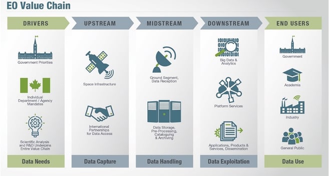
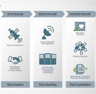
At its core, the Earth Observation (EO) spatial data value chain consists of four main stakeholders:
Upstream
(Data Providers)


Organizations that develop, launch, and operate satellites, such as NASA, and ESA. These entities generate raw space data through technologies like remote sensing, optical imaging, and synthetic aperture radar (SAR), providing foundational information for downstream applications.
Intermediaries
(Data Processors)
Companies like CNES, the Copernicus program and Consultancy providers that act as enablers, refining raw spatial data into structured, accessible formats. These organizations ensure that spatial data is standardized, cleaned, and made actionable for end users, facilitating adoption across industries.
Organizations like Synomen, Kermap, or Kayrros that transform spatial data into industry-specific insights. They apply AI, geospatial analytics, and predictive modeling to extract meaningful insights from raw datasets, creating services tailored to business needs.
Downstream
(Value-Added Providers)
End-Users
(Industry Clients)
Businesses in finance, insurance, agriculture, logistics etc. planning that integrate spatial data into their decision-making processes. These clients leverage processed geospatial insights for applications such as risk assessment, precision agriculture, and infrastructure monitoring.


Spatial Data Value Chain (EO)
Agence Spatiale Canadienne (ASC)